VFE Resources: Assessments & Student Materials

Here you will find some resources for student use. More can be found in the VFE Database, and more will be added as the project moves forward.
Assessments & Student Materials
About the VFE Templates
VFEs are often technological “mash-ups” involving more than one kind of software. The templates below offer a good place to start.
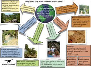
The templates provide both technological support for creating a VFE quickly and conceptual support for developing the skills for reading a landscape. In any of the three templates below, the author substitutes in pictures of their chosen field site and adapts the questions as appropriate to the unique features of the site. Thus it’s intended to be fairly straightforward technologically. The templates all share a common set of questions that can be asked about any site and that support the project’s driving question: Why does this place look the way it does? That’s part of the conceptual support that indicates that there are questions that can be productively investigated for any site on Earth.
The PowerPoint and Keynote versions of the template were produced first and include some more introductory information than is currently in the Prezi version, but the Prezi offers certain advantages over PowerPoint or Keynote. PowerPoint has the distinct advantage of being more familiar to most users.
Virtual Fieldwork Experience Development: An Introduction & Brief How-To is a nine-page pdf intended to help educators create VFEs. This was last updated in February of 2013.
In addition to the How-To pdf and these templates, we suggest the use of Google Earth or other virtual globe software in developing VFEs.
The Vfe Template for Prezi
See an extended how-to on the Prezi Template here. The Prezi version is the most current and includes an environmental science graphic organizer not included in the PowerPoint version.
VFE Template for PowerPoint & Keynote
Here’s some text from the template itself, describing its purposes and some of its limitations:
-
•This is a template for creating one sort of virtual fieldwork experiences (VFEs) of sites that are interesting from an Earth systems science perspective.
-
•It is not intended to be the only sort of VFEs, but rather might be thought of as an “entry level VFE.” The kinds of explorations learners can do in this format are real and valuable but somewhat limited.
-
•For more information about VFEs, and to download the most recent version of this template as a PowerPoint, Keynote or html file, see virtualfieldwork.org. Assessment materials are also available on the site.
-
•The pictures used in the template were taken in the Arbuckle Mountains of Oklahoma in July of 2009.
-
•The questions are intentionally written in such a way that they can be asked about any site.
-
•This is not intended as a presentation, but rather as something for learners to work through individually or in small groups. Teachers may adapt as they see fit, however.
-
•To use this as a template, simply replace the photos from the Arbuckles with photos from your own field site. All the arrows are hyperlinked. Click on them to go to a page with more on the question in the arrow.
-
•Blue boxes are hyperlinks. Links should work in all formats (html, PowerPoint and Keynote).
-
•Some pictures and text box are also linked. Move the cursor around the different slides to find links.
-
•Comments in yellow boxes are either seeking feedback on the draft or suggesting ways slides are expected be changed.
VFE Template for Prezi
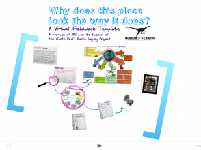
Click here or on the image of the template to see the VFE Template for Prezi. A series of video tutorials for using the Prezi VFE Template is found here.
Prezi is a presentation software that is based upon a “canvas” rather than slides. It is primarily web-based which means that the typical Prezi is available online. That allows for the author to update the presentation and have the update immediately available to any user.
The format also allows for images to be embedded within images, allowing for the easy inclusion of multiple scales. For example, a photo of a rock outcrop can have close-up images of the rock face to allow for going from seeing the entire outcrop to seeing individual grains or crystals within it. Micrographs can be includes as well.
Links to other resources, like Google Earth files or relevant websites can also be included. Youtube videos can be directly embedded within presentations, and, flipping things around a bit, Prezis may be embedded within Google Earth placemarks, by simply pasting the embed code for a Prezi into a Google Earth placemark.
Field Notebook
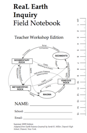
A key idea of virtual fieldwork is the simulation of actual fieldwork. A field notebook is a common, perhaps essential, geologist’s tool. This resource is intended for extended use, over the course of months. It can be used for both virtual and actual fieldwork.
This is adapted from work by Sarah R. Miller.
The Field Notebook is formatted for printing as a booklet. Follow printing directions found here. Download the file as a .pdf or a .doc. Formatting is best in the pdf version, but .doc version allows for customization.
Generic VFE questions
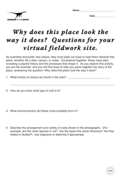
There are certain questions geoscientists ask of any field site. The questions on this student handout is intended to capture the basic questions that lead to the development of the story of a landscape. There are eight questions:
-
1. What kind(s) of rock(s) are found in the area?
-
2. How do you know what type of rock it is?
-
3. What environment(s) did these rocks probably form in?
-
4. Describe the arrangement and variety of rocks shown in the photographs. (For example, are the rocks layered or not? Are the layers the same thickness? Are they folded or faulted?) Use diagrams or sketches if appropriate.
-
5. Are there fossils in the rocks? If so, what can the fossils tell us about the age of the rock or the environment in which the original organism lived?
-
6. Tell a story of how these rocks may have formed, referring back to the photographs and what you have determined about the rock and fossil sample(s).
-
7. (a) What has happened to this area to make it look the way it does today? That is, what has happened to the area since the rocks formed? (b) Why do you think so (what is the evidence for your claim)?
-
8.If you could go to the site, what else would you want to do or see to answer the above questions?
Fieldwork Graphic Organizer
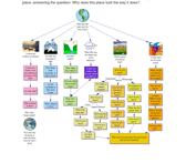
It is also included as part of the introduction to the VFE of Norwich, NY.
Specimen Label
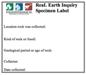
They print six to a page.
Click on the image to download this as a Microsoft Word document or here to download it as a .pdf.
Evidence Cards
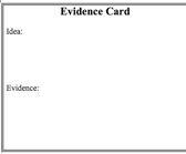
This version has no blank for names. You might use this to quickly assess class-wide understanding and use a version with names for tracking individuals’ understandings. Click on the image to download this as a Microsoft Word document or click here to download it as a .pdf.
Last Updated: August 4, 2014


